Contents tagged with wreck_diving
-
Hungarian contribution to the visualization of the wrecks of HMS HAWKE
Today, 110 years ago, on October 15, 1914, the British cruiser HMS HAWKE sank as a result of an attack by the German submarine U-9. More than five hundred British sailors lost their lives in the disaster. The wrecks were found and explored in August this year by the Scottish diving team called Gasperados, led by Steve Mortimer, based on historical research by Kevin Heath, founder of the Lost in Waters Deep website. The results of the work done by the divers in the depths were summarized by the president of our association, dr. Tamás Balogh, who prepared the report of the expedition and the very first illustrative graphic representation of the wreckage, which National Geographic Hungary Magazin will present to the interested public in commemoration of the anniversary.
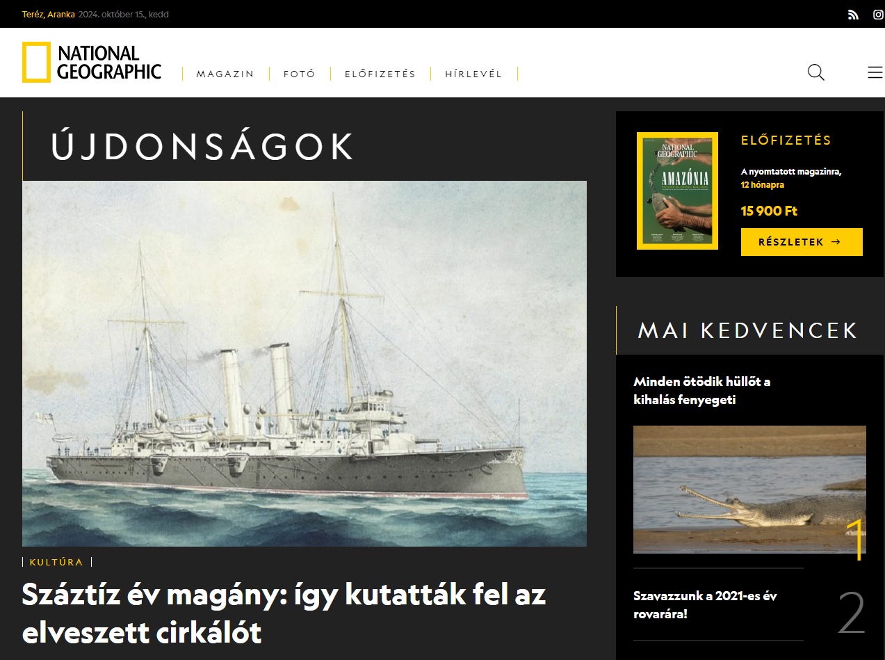
Figure 1: The sinking of HMS HAWKE in the second month of World War I. was as unexpected and sensitive loss for the British Navy as the loss of the cruiser SMS ZENTA was for the Austro-Hungarian Monarchy in the prelude of the War. The search for her remains now marks the end of a long story by identifying the final resting place of the victims, which has been unknown for more than a hundred years.
The story can be read in Hungarian on the magazine's website: here.
The full text of the article is available in English: here.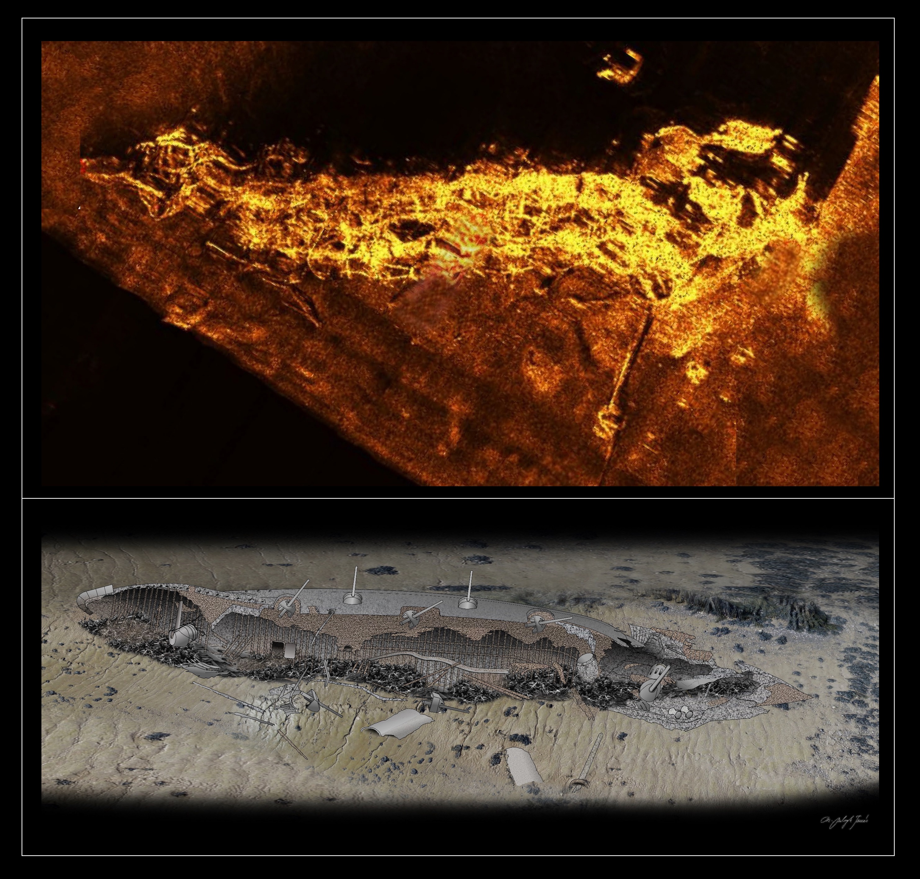
Figure 2: SONAR recording of the wreckage of HMS HAWKE (above) and a digital drawing illustrating the position and condition of the wreck, created by Dr Tamás Balogh.
-
Further secrets of the LUSITANIA in the National Geographic Magazine
The remains of the British giant steamer LUSITANIA, resting in the Atlantic Ocean, were visited again between July 13-21, 2023 by the the international expedition, which began in 2022, and was the first which had that most important task is the internal research of the areas affected by the explosion of the torpedo that sank the ship, and which for the first time in the history of the research of the wreck, included Hungarian members. On this occasion, the president of our association Dr. Tamás Balogh, who participated in the expedition by evaluating the underwater photoes and footage made by the divers, wrote an article, which can now be read on the website of the Hungarian edition of the National Geographic Magazine.
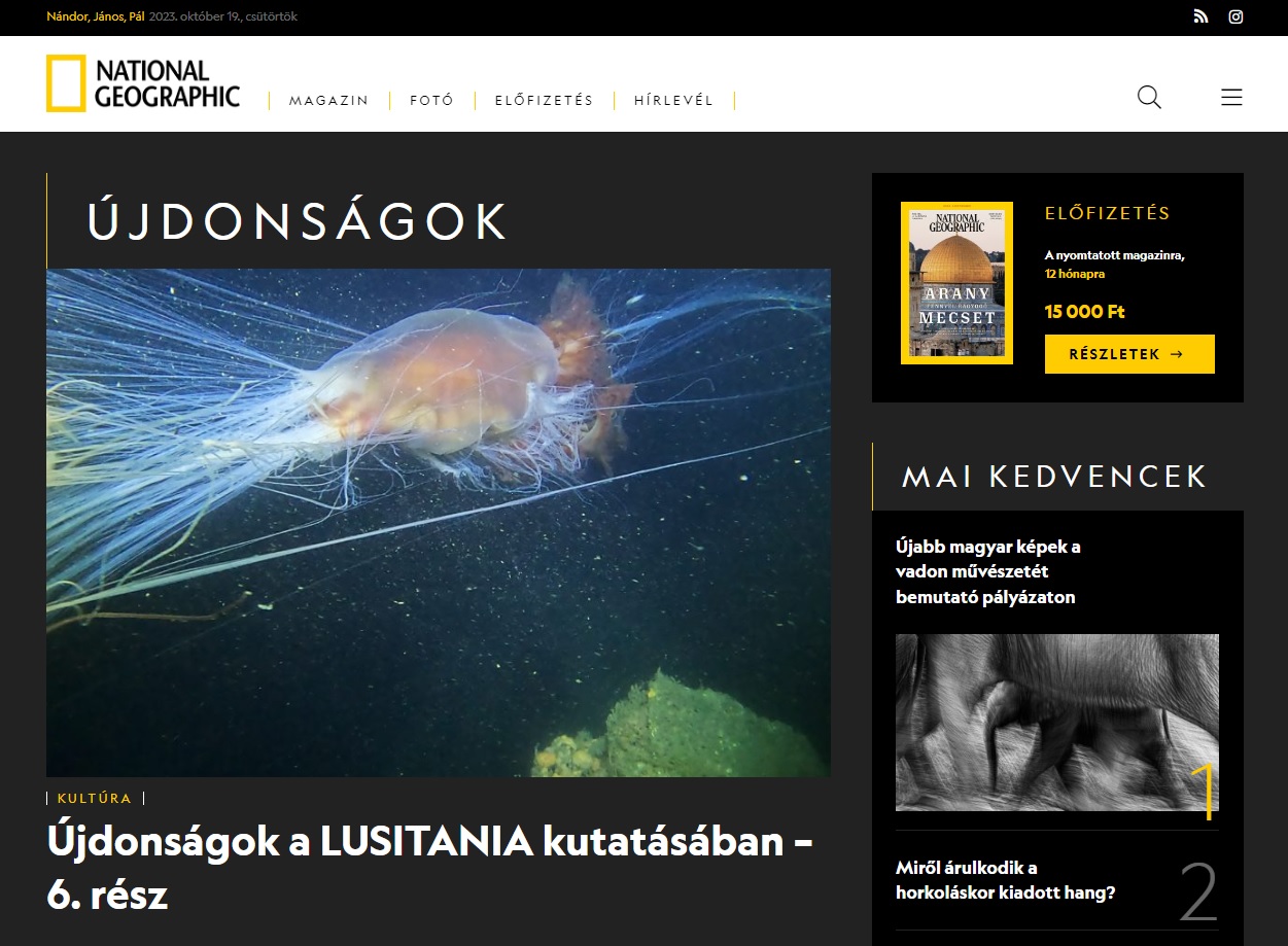
Fig. 1: LUSITANIA is on the cover.
An article summarizing the latest research results is available
in Hungarian here
in English here.
By comparing all of this with a similar report on the 2022 research, readers can get a complete over-all picture of the wreckage of the LUSITANIA.
Below we share some drawings made by hand on site during the expedition, which show the state of the ship's bow section in 1915, immediately after the sinking of the wreck, and today, in 2023, which was in the focus of the 2023 expedition.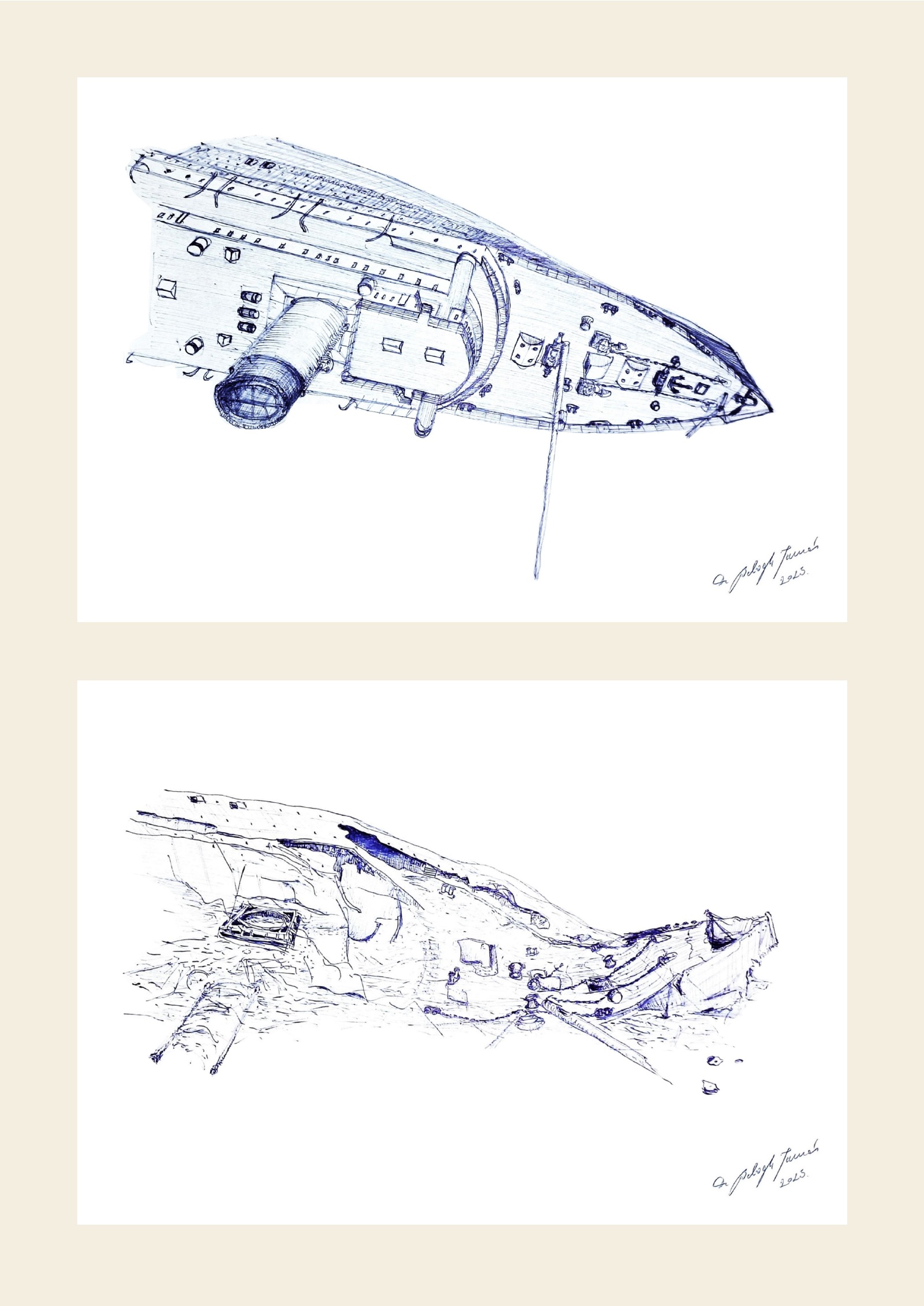
Fig. 2: The bow of the LUSITANIA on the seabed as seen from the bow deck in 1915 (above) and in 2023 (below). Created by Dr. Tamás Balogh © 2023.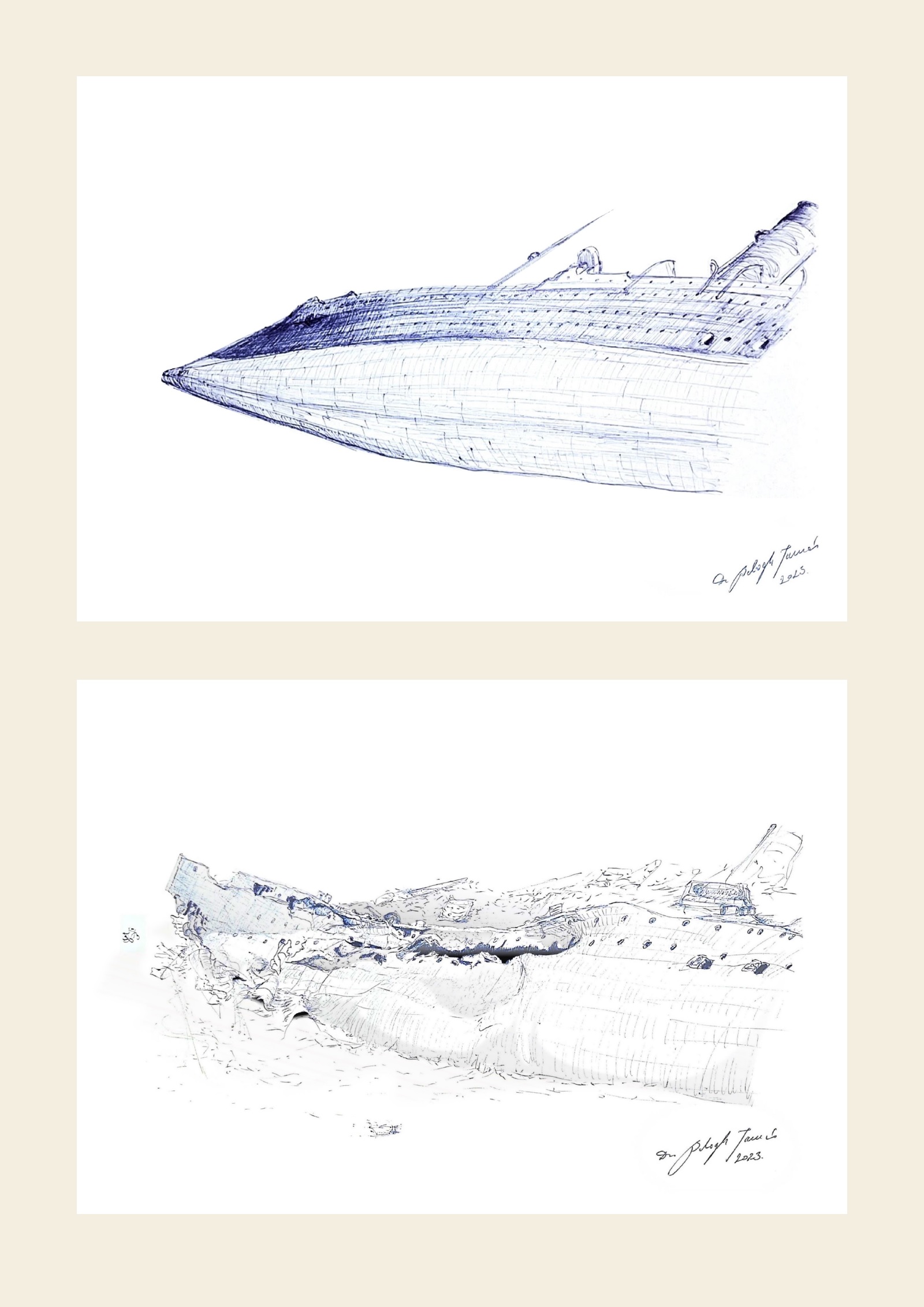
Fig. 3: The bow of the LUSITANIA on the seabed as seen from the bottom of the ship in 1915 (above) and in 2023 (below). Created by Dr. Tamás Balogh © 2023.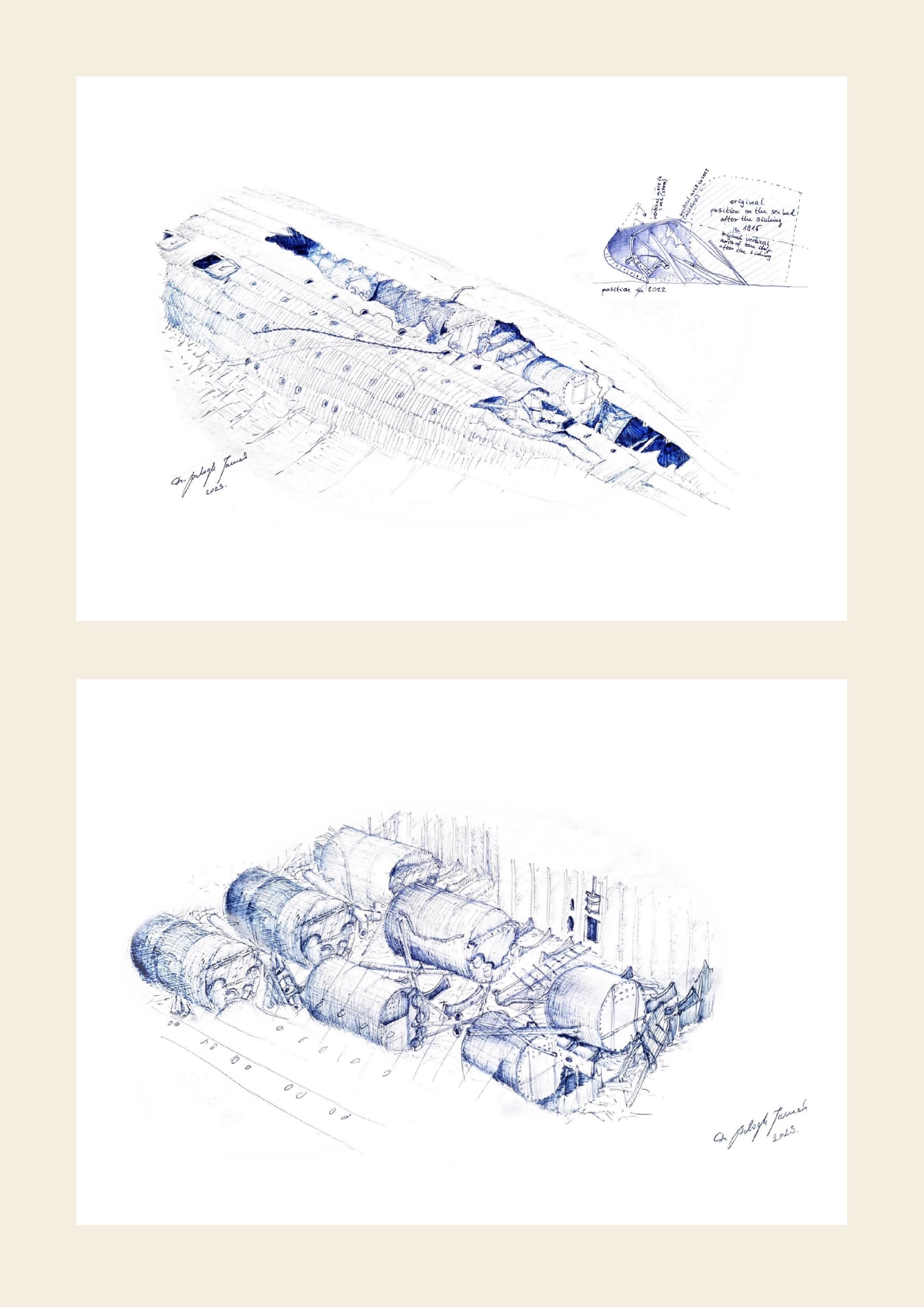
Fig. 4: The hull-section of the boiler room No 1. of LUSITANIA viewed from the top of the wreck (covered by the plates of the former port side) in 2023 (above) and the boilsers inside, "looking in" under the plates (below). Created by Dr. Tamás Balogh © 2023.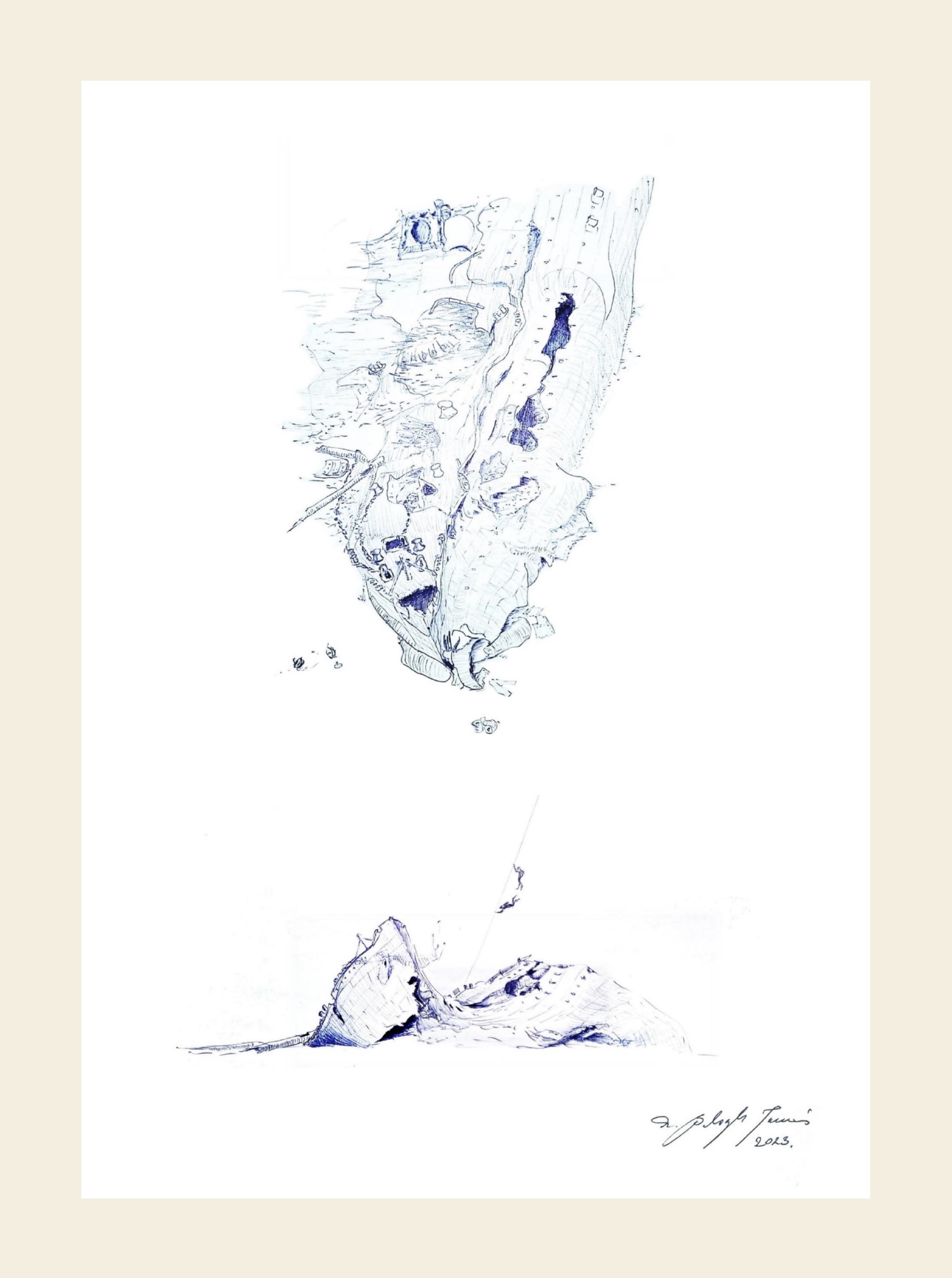
Fig. 5: An overview of the wreckage of the LUSITANIA seen from the bow in 2023. Created by Dr. Tamás Balogh © 2023.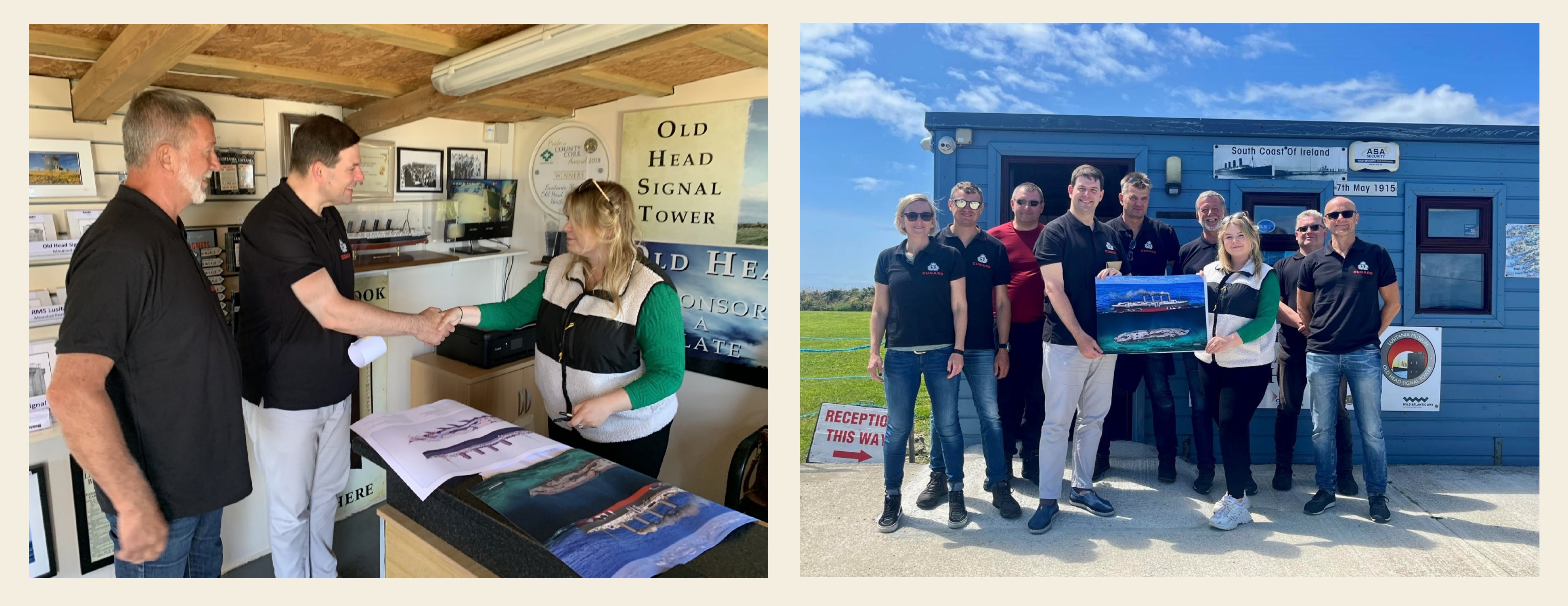
Fig. 6: Tamás Balogh presents his images made of the LUSITANIA ocean liner and its wrecks to Shannon Forde, director of the Lusitania Museum & Old Head Signal Tower (owner o the wreck), in the company of the expedition leader, Stef Teuwen (left), and the ceremonial handing over of the images together with the members of the expedition in front of the ticket office of the Museum (right).
It would be great if you like the article and pictures shared. If you are interested in the works of the author, you can find more information about the author and his work on the Encyclopedia of Ocean Liners Fb-page.
If you would like to share the pictures, please do so by always mentioning the artist's name in a credit in your posts. Thank You!
-
Stunning new album shows history of Scandinavian shipwrecks
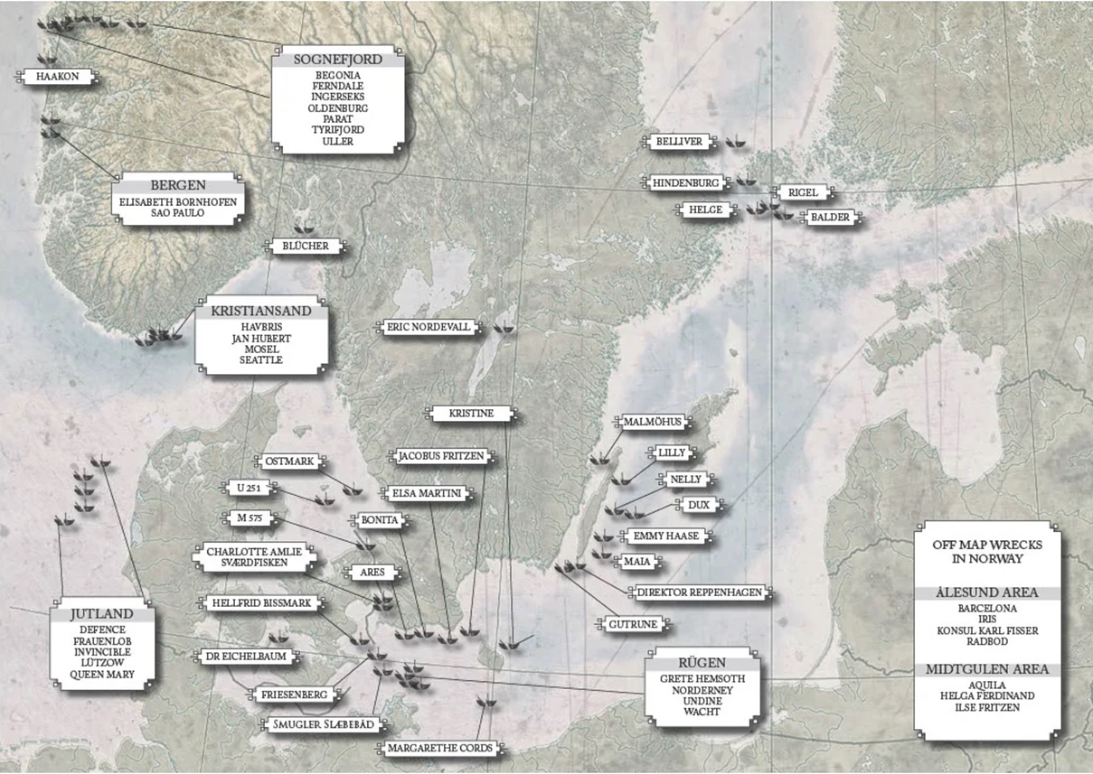
I had a pleasant surprise this week when Danish diver and underwater photographer René B. Andersen sent me some photos showing a few pages of his new book. The photos shows pages with the wreck drawings I made of the shipwrecks visited by the 2016 Jutland Centenary Expedition in which we were both participated. The drawings provide an overview of the shipwrecks presented by René's stunning underwater photographs in the new two-volume book on the shipwrecks of Scandinavia
The book, titled "Legends Beneath the Waves - Scandinavia I. II." was published in November 2022. Its authors are the Danish underwater photographer René B. Andersen and the American Andrew Marriott, the editor of DivePhotoGuide, a portal specializing in underwater films and photos, himself a diver.
The two-volume work is full of the most amazing underwater wreck photos, taken in seven major regions of Scandinavia and showing 60 shipwrecks: 1) 5 shipwrecks in the Åland Islands, 2) 8 shipwrecks on the island of Gotland, 3) 12 shipwrecks in Skåne and Rügen, 4 ) 7 shipwrecks in the Skagerrak and Kattegat regions, 5) 5 shipwrecks in Jutland, 6) 15 shipwrecks in southern Norway (in the region of Kristiansand, Bergen and the Sognefjord), and 7) 8 shipwrecks in Central Norway (in the region of Alesund and Midtgulen).
The underwater shots is complemented by stories and background information based upon the results of thorough historical research. The wrecks presented in the book lie at a rather great depth, and their approach was possible with use of rebreathers and at the cost of many hours of decompression.
The books are in A4 format, full of color pictures and both have 272 pages, so they weigh 4.5 kg. It's a heavy but all the more beautiful read... I'm glad I could contribute to its creation.
Big congratulations to the creators!
More information about the book:
https://www.youtube.com/watch?v=ccKUuWwznik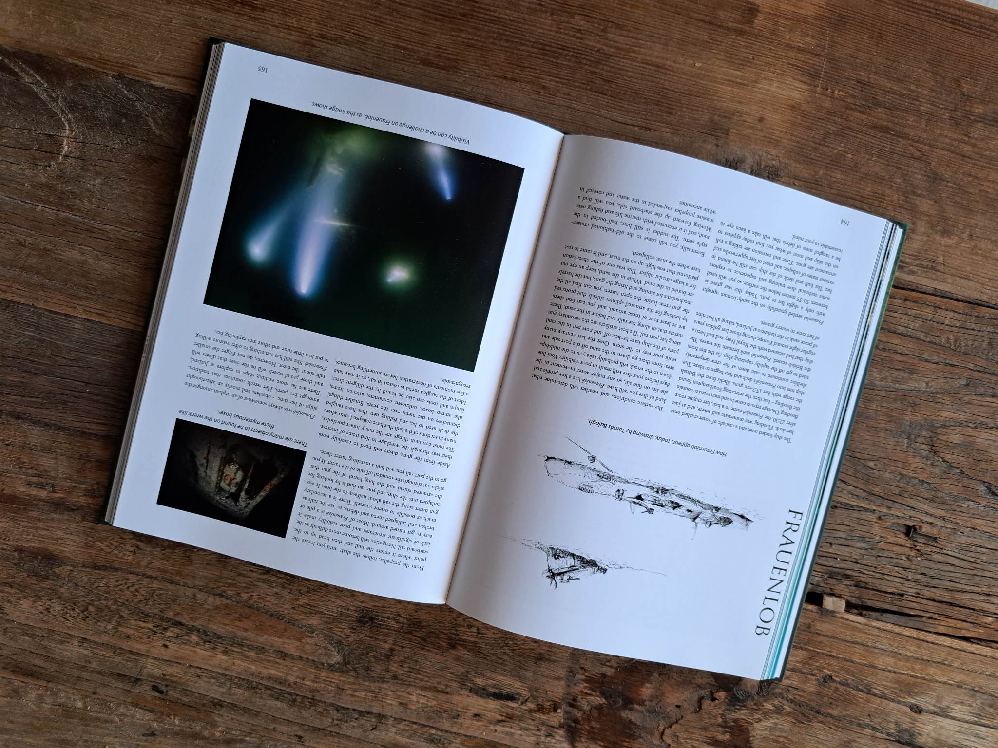
-
National Geographic Magazine reports on the secrets of LUSITANIA
The remains of the British giant steamer LUSITANIA, resting in the Atlantic Ocean, were visited by the first expedition, which included both German and Hungarian members between July 6-14, 2022, of which members for the first time managed to get into the No. 1. boiler room of the ship and explore it thoroughly. On this occasion, the president of our association Dr. Tamás Balogh, who participated in the expedition by evaluating the underwater photoes and footage made by the divers, wrote an article, which can now be read on the website of the Hungarian edition of the National Geographic Magazine.
Fig. 1: LUSITANIA is on the cover.
An article summarizing the latest research results is available
in Hungarian here
in English here.
Below we share some drawings made by hand on site during the expedition, which show the state of the wreck in 1915 immediately after the sinking, and today, 2022, of the stern of the ship, which was the research area of the first half of the 7-day expedition.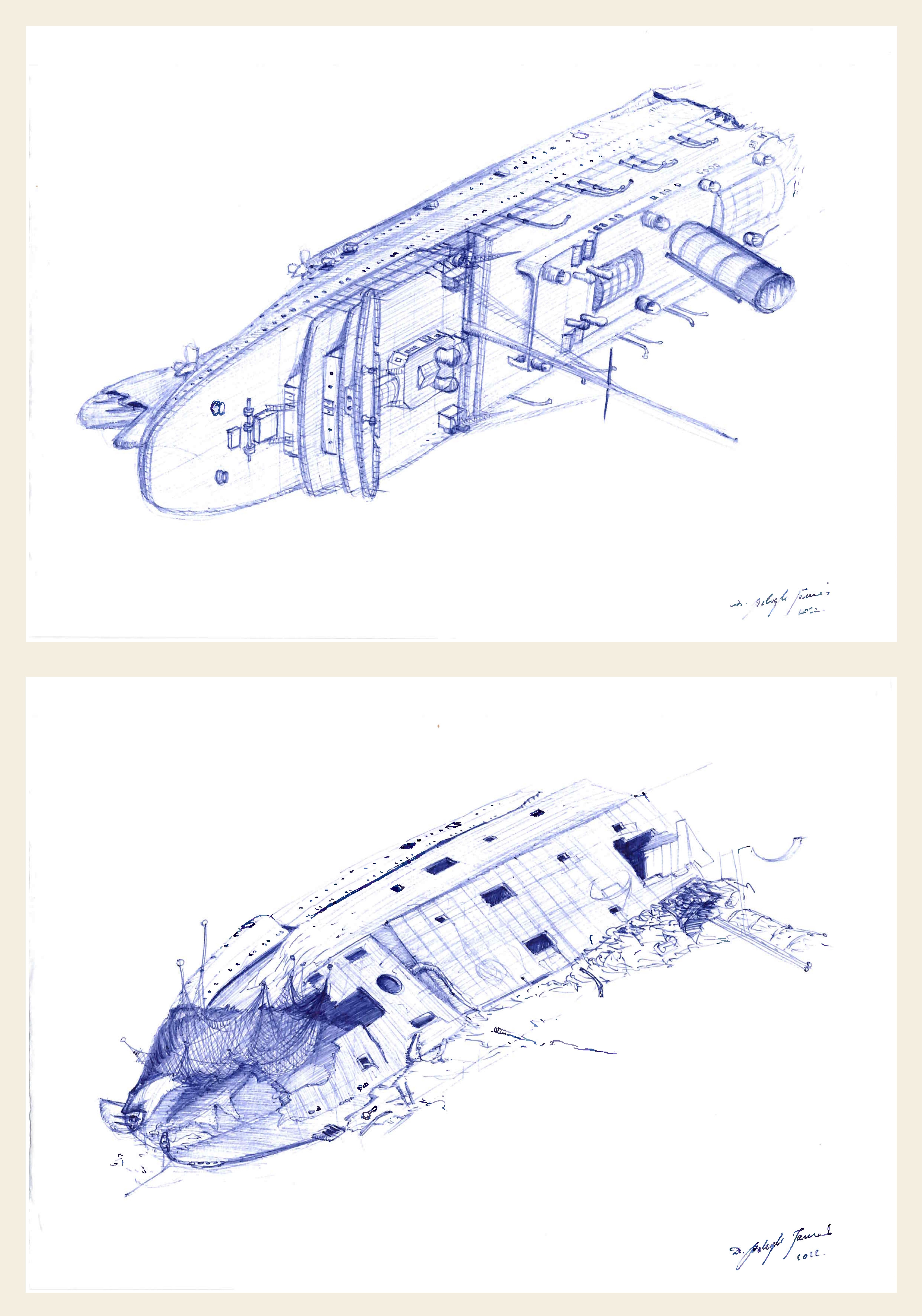
Fig. 2: The stern of the LUSITANIA on the seabed as seen from the boat deck in 1915 (above) and 2022 (below). Drawing by Dr. Tamás Balogh © 2022.
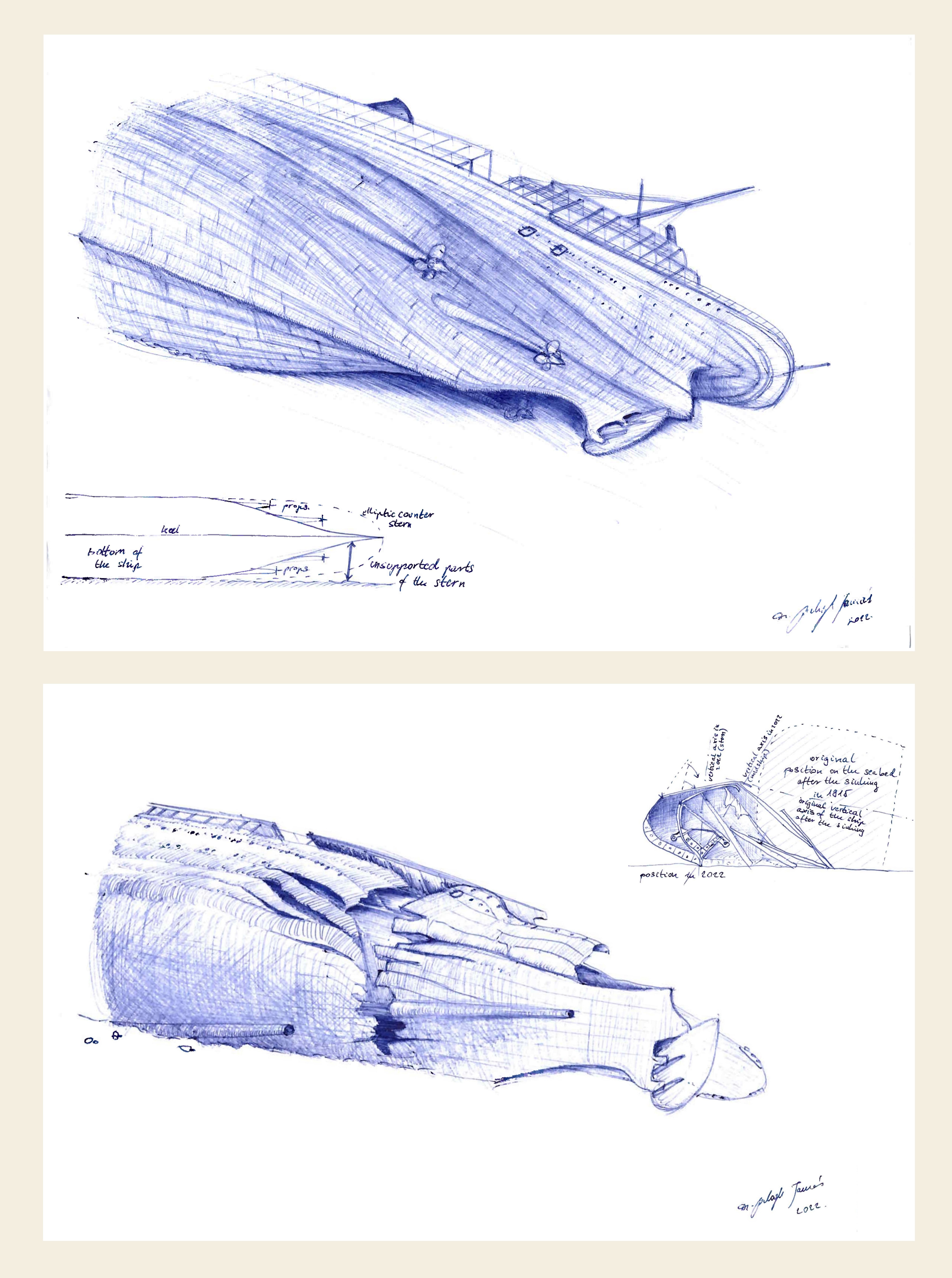
Fig. 3: The stern of the LUSITANIA on the seabed as seen from the bottom of the ship in 1915 (above) and 2022 (below). Drawing by Dr. Tamás Balogh © 2022.

Fig. 4: An overview of the wreckage of the LUSITANIA seen from the bow in 2022. Drawing by Dr. Tamás Balogh © 2022.
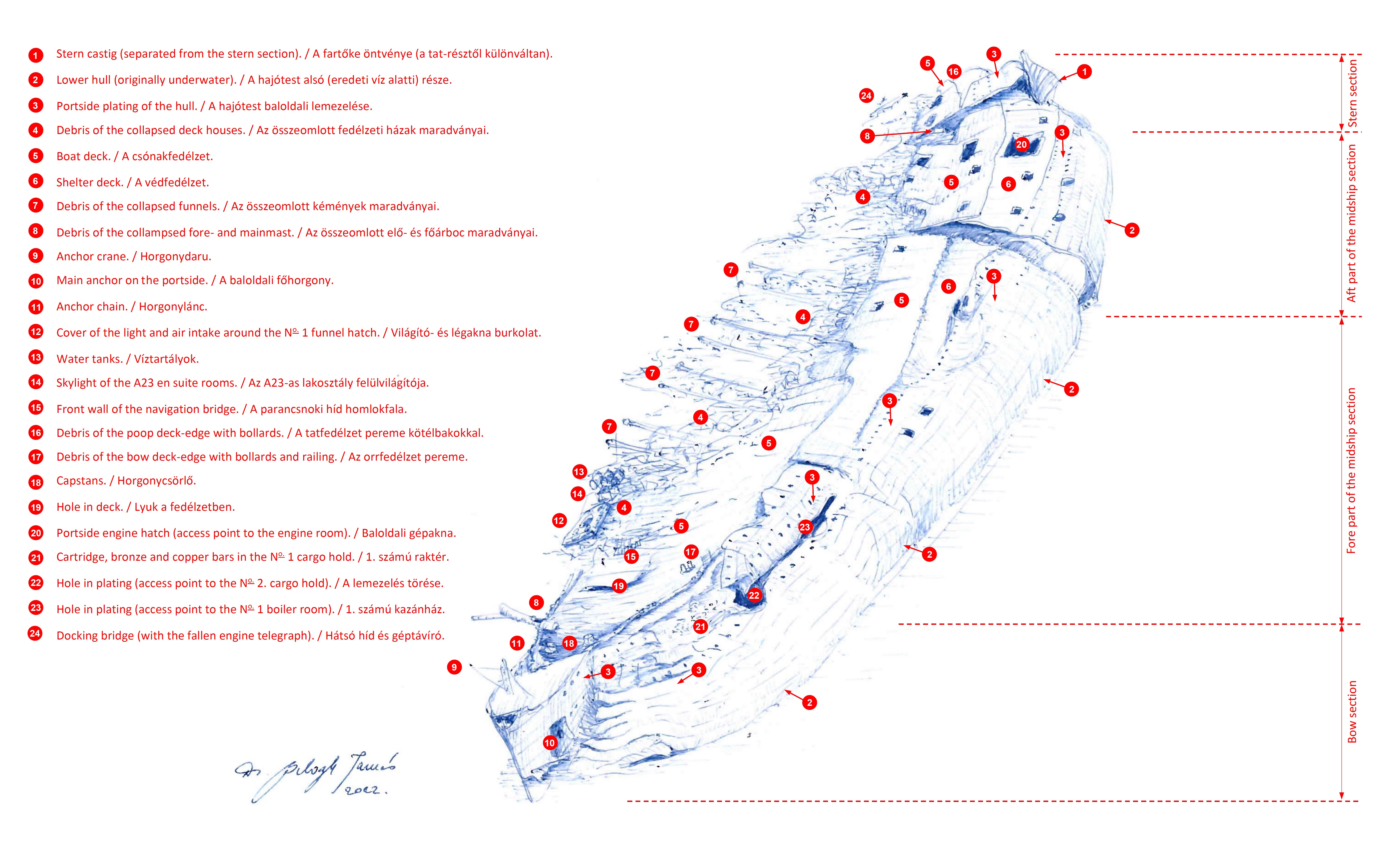
Fig. 5: The points visited by the expedition on the wrecks of the LUSITANIA. Drawing by Dr. Tamás Balogh © 2022.
It would be great if you like the article and pictures shared. If you are interested in the works of the author, you can find more information about the author and his work on the Encyclopedia of Ocean Liners Fb-page.If you would like to share the pictures, please do so by always mentioning the artist's name in a credit in your posts. Thank You!
-
Shipwreck Scanning - Development of Underwater Archeology Visualization Toolkit Today
On May 1, 2021, Gerard Dooly, a researcher at the University of Limerick in Ireland and a fellow at the University's Mobile and Marine Robotics Research Center, initiated a live broadcast in order to present those underwater survey/visualization infrastructure, which is currently in use for the exploration of the remains of H.M.T. JUSTICIA and H.M.S. AUDACIOUS (largest World War I shipwrecks off the north coast of Ireland) on the North Atlantic. In that broadcast participated a technical diver, diving instructor and wreck photographer, Barry McGill, owner of Indepth Technical Diving, and Tamás Balogh, the president of our association.

Figure 1: Participants in the conversation, Tamás Balogh (left) and Barry McGill (right), while analyzing footage taken during a dive at the wrecksite of JUSTICIA (ex-STATENDAM). The full conversation can be downloaded here.
In 2005, the Geological Survey Ireland and the Marine Institute set up the Integrated Mapping Program for the Sustainable Development of Ireland's Marine Resources (INFOMAR) as a follow-up to the Irish National Seabed Survey (INSS) focusing on the development of products for the integrated imaging of the physical, chemical and biological characteristics of the coastal seabed. The total map coverage of the INSS by the end of 2005 was 432,000 km2, which is 81% of the seabed area of Irish territorial waters. INFOMAR is the largest seabed survey program currently underway in the world. Not only in terms of its geographical scope, but also in terms of its dynamizing impact on a wide range of science, the economy and society. The program helps to understand the seabed's fauna, ecosystem, economic treasures, structural morphology, as well as the development of mapping and visualization applications and robotics (unmanned underwater vehicles), as well as the relationship between research and business in the field of newly developed solutions for production. and industrial application). One important partner in the implementation of the INFOMAR program is the University of Limerick, whose Mobile and Marine Robotics Research Center (MMRRC) is developing the infrastructure for the mapping program.
One of the important beneficial side effects of a large-scale integrated marine resource assessment program is the collection of position and depth data essential for shipwreck mapping and the production of three-dimensional seabed and wreck maps produced with high-efficiency sonar equipment. As a result, we now know exact datas of 270 shipwrecks out of some 15,000, in the waters around Ireland, mostly from the First and Second World Wars. Of these, 90 are located in the vicinity of the Malin Head, and 46 of them are also known by name. One of these 46 shipwrecks is the H.M.T. JUSTICIA (ex-s.s. STATENDAM) ocean liner and H.M.S. AUDACIOUS dreadnought-type battleship, the remains of which lie near the northernmost point of the island of Ireland, the Malin Head, at a depth of 68 m.
Barry McGill has long been a regular participant in the research of historic shipwrecks near the Malin Head, and together with Tamás Balogh they participated in a 2019 expedition researching the wreck of H.M.T. JUSTICIA. The two researchers commented on the images transmitted from the site during check-in by a research team led by Ger Dooly, while the expedition is currently examined the wreck of the H.M.S. AUDACIOUS (H.M.T. JUSTICIA was examined on the previous day).
H.M.S. AUDACIOUS was one of the newest (1912 built) dreadnought type British battleships (like the Austro-Hungarian SZENT ISTVÁN). On the morning of 27 October 1914, barely three months after the outbreak of World War I, she ran onto a sea mine, layed by the german minelaying ship S.S. BERLIN (converted passenger liner) off the north coast of Ireland . The sea-mine exploded on the left side of the battleship, under one of the engine rooms (unfortunately, just 3 feet in front of the engine room’s rear watertight bulkhead), so only the center and right engine rooms continued to function. The ship tilt increased until 15 degrees (which was decreased to 9 degrees by counter-flooding) continued her way at reduced speed and ask for towing. Then, with the exception of the battleships, all vessels in the vicinity were ordered to rescue (due to the importance of AUDACIOUS, not caring that rescue-ships could also hit mines). The huge R.M.S., OLYMPIC, TITANIC’s sister ship was also nearby, on her way, full of passengers, also hurried to the scene, and since the battleship was still deemed rescuable, sent a tow rope over, trying to tow the H.M.S. AUDACIOUS to the nearest port. However the damaged battleship gradually became more and more flooded by the heavily waveing sea, and - when she eventually became unnavigable - her commander gave the order to abandon her. Most of the crew is picked up by the OLYMPIC. The H.M.S. AUDACIOUS was finally sunk at night, 12 hours after the mine exploded. The only victim of the incident was a petty officer of the cruiser H.M.S. LIVERPOOL, who was hit by a metal piece when the H.M.S. AUDACIOUS capsised and exploded shortly before its final plunge (as the shells - stored in the magazine of the forward gun turret - detonated and the cordite ignited by this).
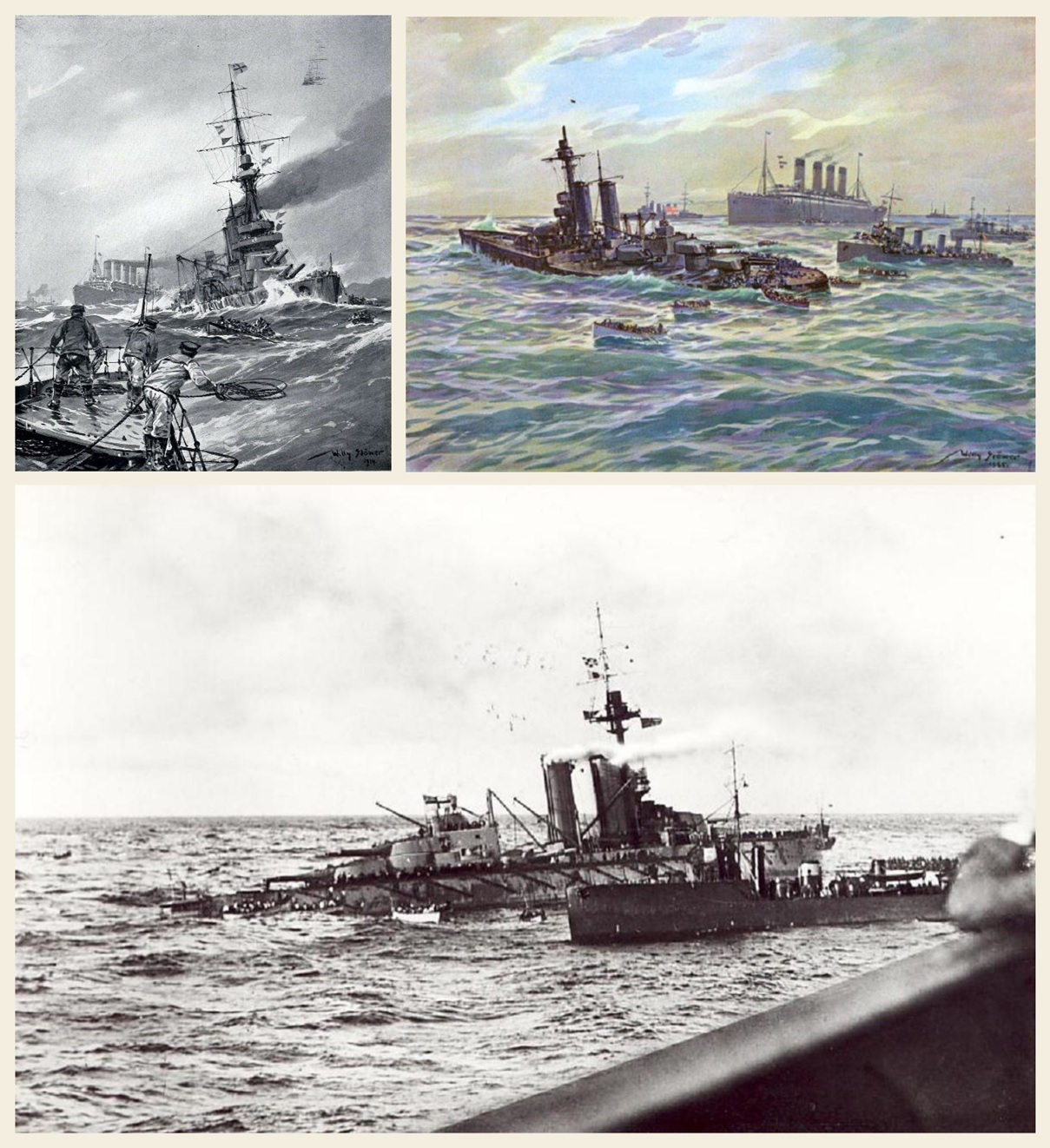
Figure 2: Contemporary painting of the H.M.S. AUDACIOUS and R.M.S. OLYMPIC made by famous German naval painter Willy Stöwer and a photograph taken by an American passenger aboard the ocean liner (in the foreground of the latter picture is the bulwark of the boatdeck, while lifeboats of the OLYMPIC can be seen at the stern of the damaged battleship).
The bow broken off due to the ammunition explosion is further away from the rest of the hull. Between the two parts of the hull lies the forward gun turret, which has fallen out of its original position, and the armored barbetta separated from it. The capsized hull is in the final stage of collapse, as the unarmoured parts of the hull gradually falls between the armored - and therefore extremely solid - side walls of the hull (the same process is just going on for similar reasons in case of the sunken Austro-Hungarian battleship SZENT ISTVÁN which is only 2 years younger than H.M.S. AUDACIOUS). Therefore, the accurate recording of the wreck and of the correlation between the parts of it, is a particularly important task, as with the final collapse, a significant part of the ship's explorable past will also be lost. With technology developed by Ger Dooly and his team, the capsized and disintegrated wreck was therefore virtually scanned. As it is a ship 182 m long and 27 m wide, this is no small task. Nevertheless, a remotely operated vehicle (ROV) wich can keep a constant depth under water and a constant distance from the wreck with the laser beam emitted by the attached detector, traveled through the wrecksite just like a 3D scanner on an object selected for digital fixing. The process thus provides a much more complete picture of the wreck and the wrecksite as a whole than what traditional diving expeditions would be able to do in the same amount of time. This technique therefore provides a more complete and detailed picture of the wreck than ever before, greatly aiding the research of them and reducing the risk of work, as the high-detail picture can be taken without even a single diver having to dive to the seafloor. This procedure is the most advanced and efficient way currently available to visually display wrecks.
The mapping of wrecks, the recording and display of data from on-site surveys has undergone long development. The first open-circuit scuba technology was designed by Jacques Yves Cousteau in 1942, and the first underwater camera was not constructed until 1963 (invented by Jean de Wouters). Until now, archaeologists involved in the work of divers have only been able to record the location and condition of a site and the finds found there, only by making drawings and reconstructive representations used in land archaeological excavations, ie by observation with the naked eye. The first major change was the underwater magnometer developed in 1953, the side-scan sonar published in 1954, and the sub-bottom profiler that has been prevalent since the 1960s. The magnetometer made it possible to separate metal and wood (so it could only be used for already known sites), and the sonar and sub-bottom profiler based on signal reflection drew the topography of the seafloor (making it easier to navigate) and helped identification of subsurface or other structures which burried with sediment. With the further development of the first underwater stereo cameras - developed between 1966-71 - the method of photogrammetry has been applied since 1991, which builds a three-dimensional image from two-dimensional photographs. Thanks to the development of 3D printing, this image itself can even be printed as well. All this helps research and museum pedagogy alike, as the finds become tangible to researchers and those interested.
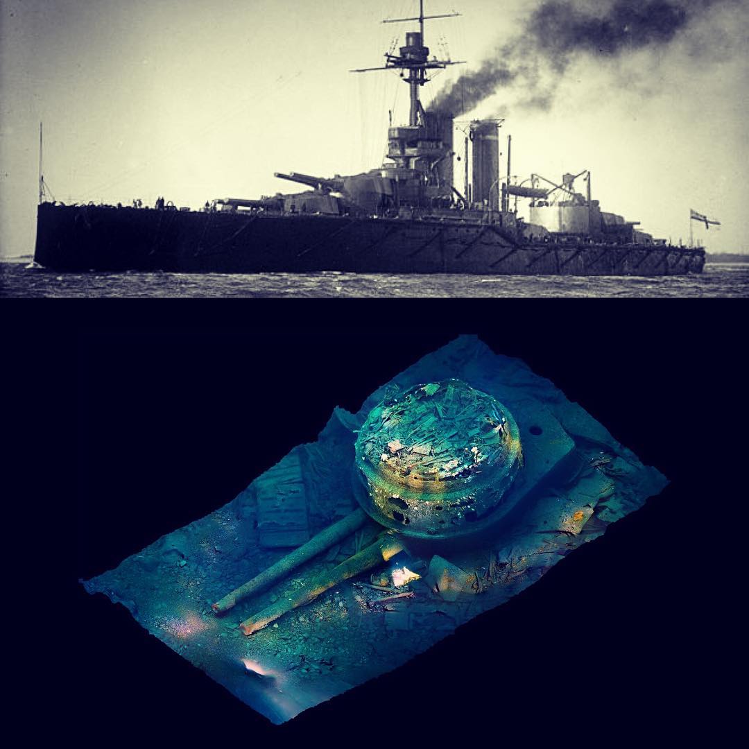
Figure 3: During the exploration of sunken remains of the TITANIC, perhaps the most famous shipwreck in the world, researchers helped in their orientation and analytical work by a huge photographic mosaics composed of many thousands photographs. However, by the advance in technology, these static, two-dimensional images have acquired a rotatable, spatial representation. You can see above the photogrammetric 3D image of the forward gun-turret of H.M.S. AUDACIOUS torn from the overturned hull (Matt Carter, Barry McGill, 2017). The rotatable 3D model is available here.
The latest generation of tools to support shipwreck research is the underwater scanners used by Ger and his team and augmented reality (the current state is complemented by virtual reality), which is capable of spectacularly visualizing changes (especially attracting young interested age groups). The connected geoinformation system - GIS - combines and transforms the data extracted through all these tools and procedures into a database, which (even in the current live broadcast) can be freely forwarded, so it is one of the most effective tool for information sharing, which is one of the most important goal of the archeology in addition to information acquisition (survey and documentation).
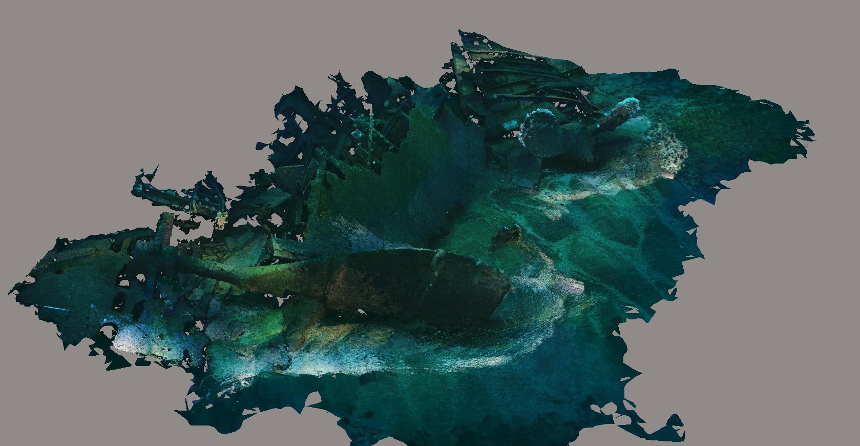
Figure 4: Results of a photogrammetric survey of the stern section of the JUSTICIA's (ex-STATENDAM's) wreck according to the progress made in July 2020. In the foreground of the picture is the rudder blade attached to the left-tilted stern post, and to the right in front of that (closer to the upper edge of the picture) are the two blades of the right propeller which is partially buried by the sediment. (Source University of Limerick, Ger Dooly, Indepth Technical Diving, SANTI diving TEAM, SANTI Diving, Big Blue Dive Lights).
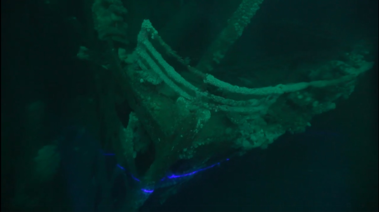
Figure 5: The underwater laser scanner in work, the at the tip of the bow of the JUSTICIA's wreck. Source.
During the conversation that accompanied the spectacular presentation, Barry McGill reported details of a series of research on the wreckage of H.M.S. AUDACIOUS, demonstrating how the strong current that can be felt everywhere in the shallow sea makes it difficult for divers, who can be swept away from their desired position on the one hand, and blinded them on the other hand by the sediment and by the fine-grained rust (which rises in clouds from the wreck during the sudden collapse of a larger structural element), kept in motion by the current, minimizing the visibility. At the same time, Barry did not fail to mention that the wildlife of the continental shelf is also present on the wreckage and sometimes a seal appears among the remains.
Tamás Balogh emphasized the importance of H.M.T. JUSTICIA (ex-STATENDAM), in this context, addressing in particular why the ship is often referred to as the “Dutch TITANIC”. With the scheduled construction of the sister ships OLYMPIC, TITANIC and GIGANTIC, the Harland & Wolff Shipyard in Belfast is prepared to mass-produce the highest quality ocean liners for any nation in the world. Thus, when the Dutch also ordered the type, the shipyard made - on the basis of TITANIC's plans - a slightly smaller vessel (which was the first ship constructed after the TITANIC's launch), optimized for shallower Dutch waters. In addition, the ship was the largest shipwreck sunk by torpedoes in World War I, and the infamous wolf pack tactics of the German submarines of World War II, were created during the sinking of this ship. However, the fierce German attempts to sink the ship at all costs was the result of a misidentification, when Otto von Schrader, the commander of the first German attacker, U-64, confused her with the similar German ocean liner VATERLAND (which remained in the neutral USA at the outbreak of the war, but by 1918, however, she had already transported American soldiers across the ocean against Germany, so the submarines of the German Navy competed with each other to try to sink her as soon as possible).
At the end of the conversation, Ger Dooly emphasized that they wanted to make it possible to apply this spectacularly advanced technology widely, thanks to the partnership of the university. (We note that this technology - with proper foresight and some luck - can even be used in the research of historical shipwrecks important to Hungary, such as the battleship SZENT ISTVÁN, which is a contemporary of H.M.S. AUDACIOUS). The interlocutors then thanked for the spectacular presentation. Barry expressed the hope that the survey, which had begun at the two major sites, could be continued out together as soon as possible and, if possible, that the technology could be used in the exploration of another historic wreck, the LUSITANIA, near to the south coast of Ireland. Tamás Balogh pointed out that a thorough photogrammetric and laser survey covering every detail is probably the most modern technology to implement Dr. Robert Ballard's idea from the 1990s, the virtual deep sea museum.
In any case, with the help of the presented infrastructure, anybody can take a virtual tour at any shipwreck and wreck site, and the image of shipwrecks can be maintained forever. Without having to move anything out of place, or without having to worry about the original material, which - in its previously known form - gradually disappearing during the years. In this way, this technology not only preserve the cultural heritage, but it also makes it much more spectacular than any previous visualization options, making the context easier to understand for those who are less experienced in wreckdiving. Just like the 3D reconstructive animations which shows the original appearance of the ships, of which the latest work represents the H.M.T. JUSTICIA (ex-STATENDAM) which was presented as a farewell to those who are interested in.
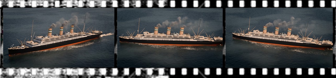
Figure 6: Some movie frames from the animation showing STATENDAM (Source: Dr. Tamás Balogh).
It would be great if you like the article and pictures shared. If you are interested in the works of the author, you can find more information about the author and his work on the Encyclopedia of Ocean Liners Fb-page.
If you would like to share the pictures, please do so by always mentioning the artist's name in a credit in your posts. Thank You!
-
Detailed overview made for the first time, mapping the wreckage of the HMHT JUSTICIA, sunk in 1918
On March 1, 2020, second episode of the "Shipwreck Secrets", of the Discovery Science TV-channel in the United States, was broadcast (will be on screen also in the rest of the world in the coming months). This second episode of the six-part series, introduces the history of the sinking of his majesty's hired trannsport vessel HMHT JUSTICIA (converted from the dutch ocean liner STATENDAM) and an on-site analysis of the wreckage off the Atlantic coast of Donegal, Ireland.
The president of our association, Dr. Tamás Balogh, who launched his book on the history of the ship at the Harland & Wolff Shipyard in Belfast in 2018, and as a result, he was invited to participate in the contribution to the production of the film. The exciting expedition and filmmaking took place in May 2019, followed by the post-production was resulted a one-hour film, which was presented to those interested on March 1, 2020.
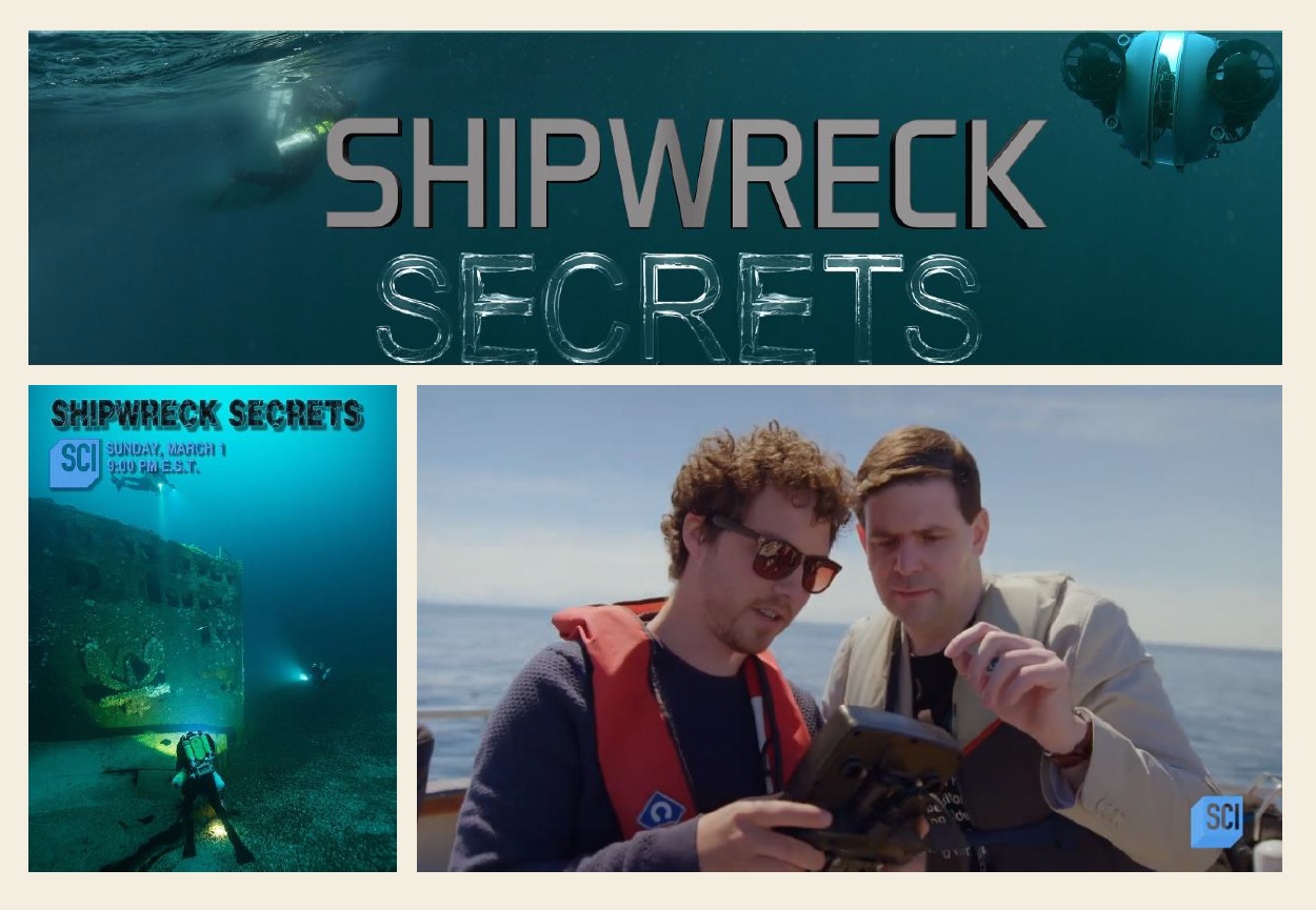
Figure 1: Logo of the TV-series, poster of the second episode, and a scene (source: Shipwreck Secrets).
The most important result of the work is that 100 years after the ship sank, the first complete and comprehensive survey of the wrecksite was completed. The exact resting place of the wreck has been identified by the divers Norman and Simon Bamford, and Leight Bishop, a well-known underwater photographer, has regularly captured great underwater photographs from the mid-1990s, which have made the ship widely known since 1998. Some details, such as the bow, were captured on iconic images and inspired dozens of divers, but little was known about the ship as a whole.
At least a comprehensive picture of the wrecksite as a whole was obtained when the first SONAR image of the wrecksite was taken in 2005 as part of the Irish National Seabed Survey. This image showed mainly the spatial location of the wreckage and the depth data, showing the lowest and highest elevations of the wreck with a color scale. Although all details are missing from this picture, some basic facts (as compared to previous close-ups made by the scuba divers) have become clear. It turned out, for example, that the ship, which is in the way of strong sea currents, had collapsed and that the once 237 m long, 26 m wide hull was scattered over a wrecksite of about 300 m long and a good 50 m wide. The currents, for example, swept the superstructure to the left side of the ship, and today only parts of the hull below the former waterline remained more or less intact. Everything else was broken into small pieces, turning the magnificent ocean liner into a jigsaw puzzle.
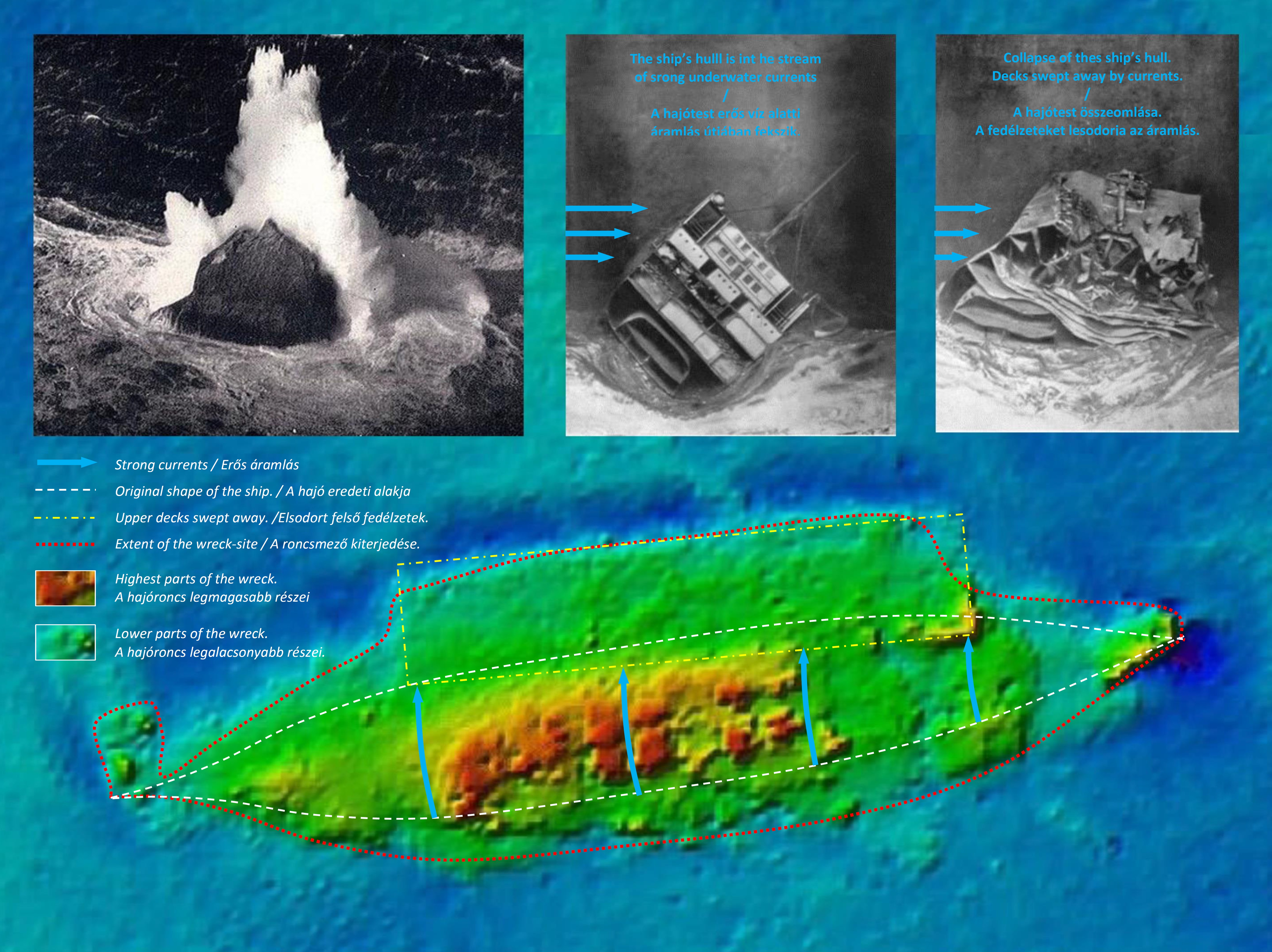
Figure 2: The SONAR image of the wreck and the main features it identifies, showing the environmental conditions leading to the collapse and the process of it (source: Dr. Tamás Balogh, using the Sonar image of INFOMAR).
Norman Woods attempted to assemble the parts of this jigsaw puzzles for the first time in 2014, capturing the underwater footage of larger areas of the wreckage by attaching his GoPro camera to his scooter, so he was able to swim along the full length of the ship from bow to stern and back again only in 13 minutes. However, he was not able to go to the sides, far away from the ship's former centerline, leaving many uncharted areas in the wreckage and waiting to be identified.
These information helped to determine the starting points of current research and to design and conduct a new survey. As a result, Dr. Tamás Balogh prepared the first complete representation of HMT JUSTICIA's resting place, which can be seen here for the first time.
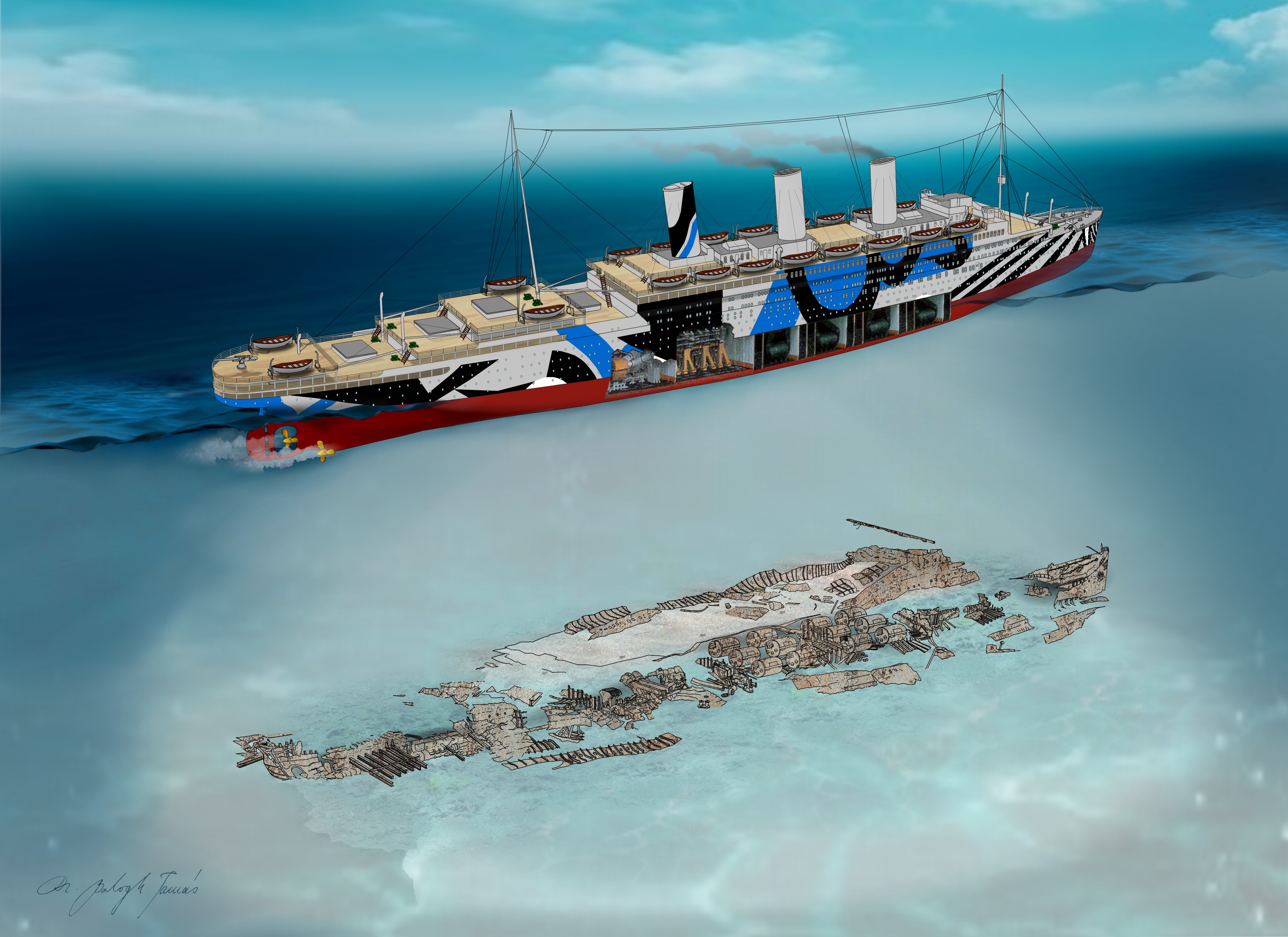
Figure 3: 1918-2018 - HMHT JUSTICIA and its Wreckage (created by Dr. Tamás Balogh, © 2020).

Figure 4: Outline drawing of the wreckage field, identifying the exact origin of the components there (by Dr. Tamás Balogh, © 2020).
By the end of the research, we were able to identify that which was the former (original) position on the ship of some larger structural units laying on the wrecksite, which also helps to better understand and reconstruct the deformation and disintegration process of the shipwreck. It was a great surprise that the walls of the watertight compartments in the lower part of the hull, can still be seen around the engines and the boiler rooms, everywhere on the ship. These walls specially strengthened after the TITANIC disaster regarding that the JUTICIA was the first ocean liner built after the sinking of the TITANIC, where the new safety regulations could be applied. Also new was the identification of the ship's fallen foremast. Unfortunately, however, it has also been confirmed that the natural deterioration of the wreck has accelerated and that even the small details that are still recognizable will soon disappear.
But before that could happen in the future, our expedition however, was able to record the condition of the wrecks and thanks to our work, the picture we know of them in 2019 is now preserved. It was a great opportunity and I'm grateful that I was able to take part in that. Thank you all!
Credits:
Filmmakers:
- Loubna Turjuman Genovese, Producer;
- Matt Bone, Producer;
- Quincy Andrews, Drone operator;
- Jonathan Young, Cameraman;
- Liam Scott, Technical support.
Divers:
- Barry McGill, Leading Diver;
- Garet O’Neil, diver;
- Stewart Andrews diver;
- Kevin McShane, Support Diver;
- Pat Coughlan Support Diver;
- Michael McVeigh, Skipper.
More about the expedition:
https://m.blog.hu/ha/hajosnep/image/008_deadly_pair_diving_in_donegal.pdf
Further wreck-diving expeditions with Tamás Balogh:
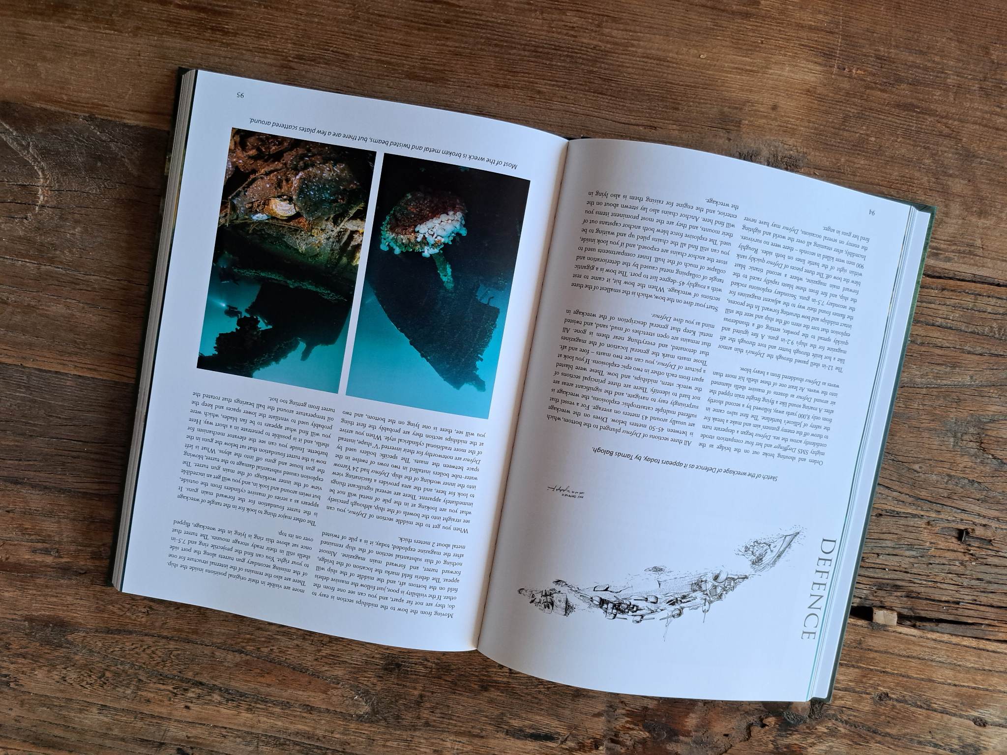
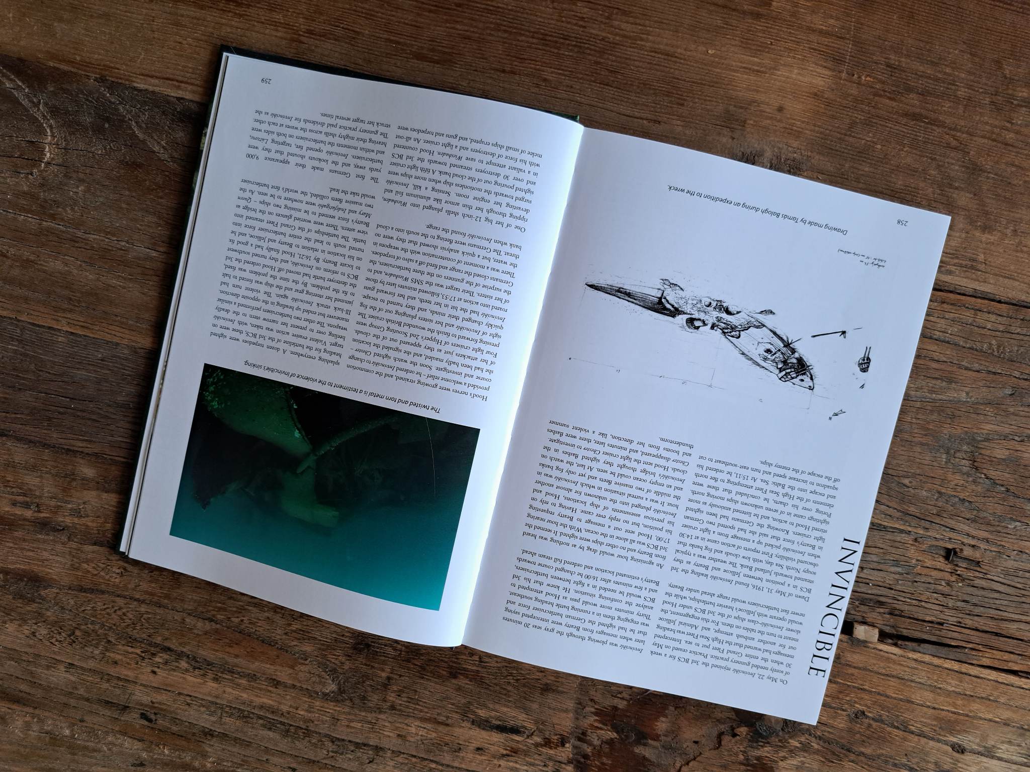
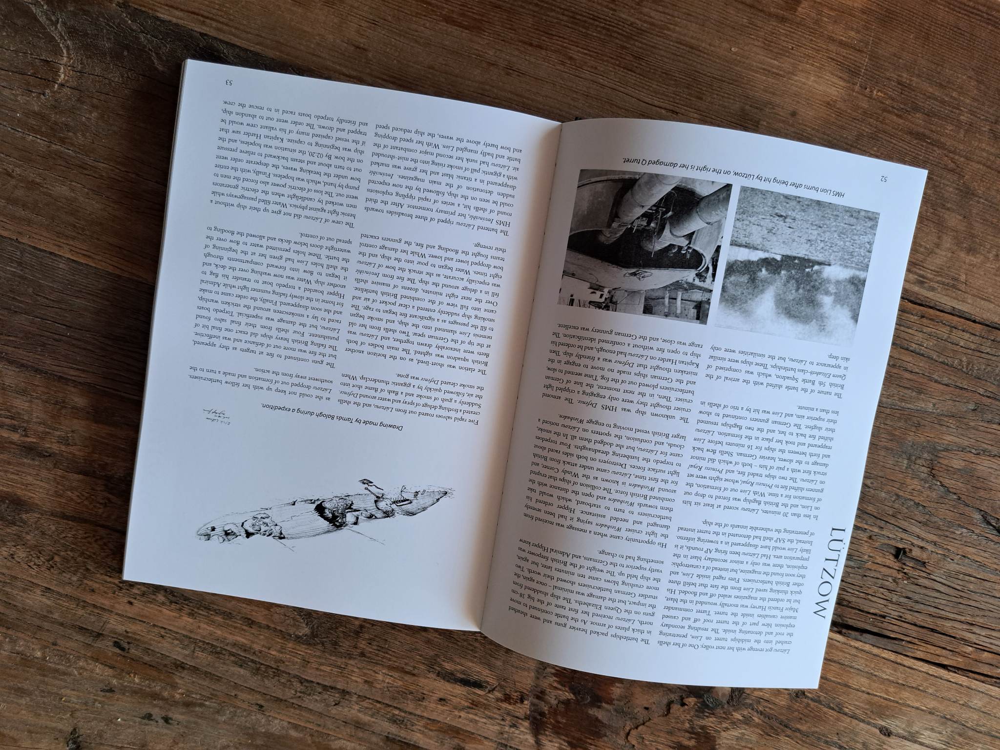
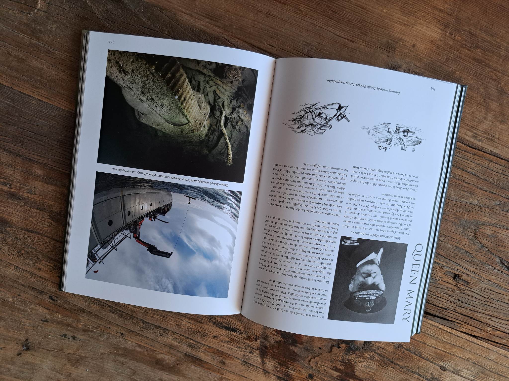
Between 2003 and 2008 he was involved in the research of the shipwrecks of the Austro-Hungarian Monarchy on the Adriatic (the destroyer STREITER, the cruiser ZENTA and the battleship SZENT ISTVÁN).
Attila Dávid Molnár made a series of films about the research (episodes made about STREITER, ZENTA and SZENT ISTVÁN were also shown on Spektrum television).
In 2016, on the 100th anniversary of the Battle of the Jutland, he was a historian of a largescale expedition with 60 divers from 15 countries and was the author of some articles on the results of the expedition.